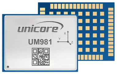
Email Us
UM981

UM981

GPS/BDS/GLONASS/Galileo/QZSS All-constellation Multi-frequency RTK/INS Integrated Positioning Module
anti jamming

Brief Introduction

UM981 is Unicore's new-generation proprietary RTK and INS integrated navigation module. It can simultaneously track multiple satellite systems and frequencies, including GPS, BDS, GLONASS, Galileo, QZSS, NavIC and SBAS. The module integrates a high-speed floating point processor and an RTK dedicated coprocessor, being able to output positioning data at 100Hz. The on-board MEMS chip and U-Fusion integrated navigation algorithm ensure continuous  positioning when loss of lock on GNSS signals occurs, providing high-quality positioning results in complex environments such as building blocks, tunnels, overpasses and tree shades. UM981 is designed for high-precision navigation and positioning applications and is ideal for high-precision agriculture applications. 


Features

  • Based on Unicore's proprietary GNSS SoC NebulasIV that integrates RF, baseband and high- precision algorithm

  • All-constellation multi-frequency RTK engine and advanced RTK technology

  • Instant RTK initialization technology

  • Excellent anti-jamming and anti-spoofing capabilities, supporting jamming detection and spoofing detection

  • Heading2 technology to provide orientation information

  • STANDALONE single-station high-precision positioning technology

  • Supports B2b-PPP and E6-HAS

  • On-board MEMS integrated positioning technology to ensure continuous positioning when loss of lock on GNSS signals occurs


Technical Specifications

Performance Specifications

Channel1408 channels, based on NebulasIV
FrequencyGPS L1C/A, L1C, L2C, L2P(Y), L5
BDS B1I, B2I, B3I, B1C, B2a, B2b
GLONASS G1, G2, G3
Galileo E1, E5a, E5b, E6
QZSS L1C/A, L1C, L2C, L5, L6
NavIC L5
SBAS L1C/A
Single Point Positioning(RMS)Horizontal: 1.5m
Vertical: 2.5m
DGPS (RMS)Horizontal: 0.4m
Vertical: 0.8m
RTK (RMS)Horizontal: 0.8cm+1ppm
Vertical: 1.5cm+1ppm
PPP(RMS) Horizontal: 5cm
Vertical: 10 cm
Attitude AccuracyHeadingRollPitch
0.3°0.2°0.2°
Positioning Error of INS only < 5 % of the distance traveled without GNSS signals
Observation Accuracy (RMS)BDSGPSGLONASSGalileo
B1I/B1C/L1C/A/G1/E1 Code10 cm10 cm10 cm10 cm
B1I/B1C/L1C/A/G1/E1 Carrier Phase1 mm1 mm1 mm1 mm
B2I/B2a/B2b/L5/G3/E5a/E5b Code10 cm10 cm10 cm10 cm
B2I/B2a/B2b/L5/G3/E5a/E5b Carrier Phase1 mm1 mm1 mm1 mm
B3I/L2P(Y)/L2C/G2/E6 Code 10 cm10 cm10 cm10 cm
B3I/L2P(Y)/L2C/G2/E6 Carrier Phase 1 mm1 mm1 mm1 mm
Time Accuracy (RMS)20 ns
Velocity Accuracy (RMS)0.03 m/s
Cold Start< 12 s
Initialization Time< 5 s (typical)
Initialization Reliability> 99.9%
Data Update Rate100 Hz (IMU RAW Data)
50 Hz* (RTK)
Differential DataRTCM V3.X
Data FormatNMEA-0183, Unicore


Physical Characteristics

Packaging54 pin LGA
Dimension17.0 × 22.0 × 2.6 mm
Weight1.91 g ± 0.03 g


Environmental Specifications

Working Temperature-40 °C ~ +85 °C
Storage Temperature-55 °C ~ +95 °C
Humidity95% No condensation
Vibration
GJB150.16A-2009, MIL-STD-810F
Shock
GJB150.18A-2009, MIL-STD-810F


Communication Interface

3 x UART (LVTTL)
1 x I2C*
1 x SPI*
1 × CAN*


Note: Items marked with * are only supported by specific firmware.

Download

CONTACT
Subscribe
Subscribe to get news updates from us
We use cookies to allow our website to function properly, personalize content,advertising, and analyze traffic. Respect for your privacy is central to our policy. Detailed information about our privacy and cookie policy can be found in the enclosed sections. Thanks in advance for your cooperation. More info...
Reject Accept