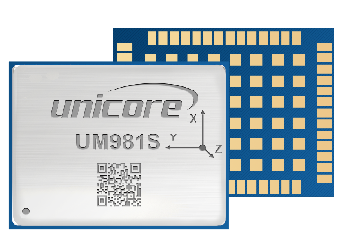
UM981S is Unicore's new-generation RTK and INS integrated positioning module. Based on the NebulasIV GNSS SoC which integrates RF, baseband, and high-precision algorithm, it is capable of simultaneously tracking GPS, BDS,GLONASS, Galileo, QZSS, NavIC and SBAS signals. The module integrates a high-speed floating-point processor, a dedicated RTK co-processor, and a built-in professional IMU, enabling RTK positioning results output at up to 50Hz and IMU raw data output at 100Hz. It incorporates the JamShield anti-jamming technology to complete enhanced multi-system multi-frequency RTK engine processing, significantly improving RTK initialization speed, measurement accuracy, and reliability in complex environments such as urban canyons and under tree shade. UM981S is designed for surveying and mapping applications and features tilt compensation capability.
Based on Unicore's proprietary GNSS SoC NebulasIV that integrates RF, baseband and high- precision algorithm
All-constellation multi-frequency RTK engine and advanced RTK technology
Instant RTK initialization technology
Excellent anti-jamming and anti-spoofing capabilities, supporting jamming detection and spoofing detection
Heading2 technology to provide orientation information
STANDALONE single-station high-precision positioning technology
Supports B2b-PPP, E6-HAS and QZSS L6E (MADOCA) PPP
On-board MEMS integrated positioning technology and tilt compensation capability
| Channel | 1408 channels, based on NebulasIV | |||
| Frequency | GPS L1C/A, L1C, L2C, L2P(Y), L5 | |||
| BDS B1I, B2I, B3I, B1C, B2a, B2b | ||||
| GLONASS G1, G2, G3 | ||||
| Galileo E1, E5a, E5b, E6 | ||||
| QZSS L1C/A, L1C, L2C, L5, L6 | ||||
| NavIC L5 | ||||
| SBAS L1C/A | ||||
| Single Point Positioning(RMS) | Horizontal: 1.5m | |||
| Vertical: 2.5m | ||||
| DGPS (RMS) | Horizontal: 0.4m | |||
| Vertical: 0.8m | ||||
| RTK (RMS) | Horizontal: 0.8cm+1ppm | |||
| Vertical: 1.5cm+1ppm | ||||
| PPP(RMS) | Horizontal: 5cm | |||
| Vertical: 10 cm | ||||
| Tilt Measurement(UM981S) | 10 mm + 0.7 mm/°tilt (accuracy < 2.5 cm within 30°) | |||
| Observation Accuracy (RMS) | BDS | GPS | GLONASS | Galileo |
| B1I/B1C/L1 C/A/G1/E1 Code | 10 cm | 10 cm | 10 cm | 10 cm |
| B1I/B1C/L1C/A/G1/E1 Carrier Phase | 1 mm | 1 mm | 1 mm | 1 mm |
| B2I/B2a/B2b/L5/G3/E5a/E5b Code | 10 cm | 10 cm | 10 cm | 10 cm |
| B2I/B2a/B2b/L5/G3/E5a/E5b Carrier Phase | 1 mm | 1 mm | 1 mm | 1 mm |
| B3I/L2P(Y)/L2C/G2/E6 Code | 10 cm | 10 cm | 10 cm | 10 cm |
| B3I/L2P(Y)/L2C/G2/E6 Carrier Phase | 1 mm | 1 mm | 1 mm | 1 mm |
| Time Accuracy (RMS) | 20 ns | |||
| Velocity Accuracy (RMS) | 0.03 m/s | |||
| Cold Start | < 12 s | |||
| Initialization Time | < 5 s (typical) | |||
| Initialization Reliability | > 99.9% | |||
| Data Update Rate | 100 Hz (IMU RAW Data) | |||
| 50 Hz* (RTK) | ||||
| Differential Data | RTCM V3.X | |||
| Data Format | NMEA-0183, Unicore | |||
| Packaging | 54 pin LGA |
| Dimension | 17.0 × 22.0 × 2.6 mm |
| Weight | 1.91 g ± 0.03 g |
| Working Temperature | -40 °C ~ +85 °C |
| Storage Temperature | -55 °C ~ +95 °C |
| Humidity | 95% No condensation |
| Vibration | GJB150.16A-2009, MIL-STD-810F |
| Shock | GJB150.18A-2009, MIL-STD-810F |
| 3 x UART (LVTTL) |
| 1 x I2C* |
| 1 x SPI* |
| 1 × CAN*(shared with UART3) |
Note: Items marked with * are only supported by specific firmware.